Geo-location

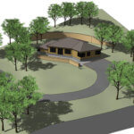
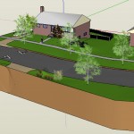
SketchUp Shadow Studies

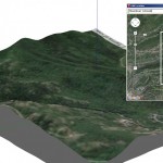
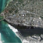
Did you know that you can easily do this in SketchUp? It’s done with scenes. Here’s how I did this example.   Geo-Location First, I needed a geo-located model. This means a model that has a defined location. Why does location matter? Because SketchUp shadows are created based on where the model is. (Place a […]

Tools on Surface Extension

I love extensions. And Tools On Surface might be my favorite (along with Soap Skin & Bubble which I’ve mentioned before and will mention again). This is one of SketchUcation’s extensions. See our post on how to get SketchUcation’s ExtensionStore. Why Tools on Surface? We all know SketchUp’s native drawing tools: Line, Rectangle, Circle, 2 […]

Skatter Extension: Part 2 - Realistic Trees and Rendering

In Part 1 of this series, I introduced Skatter, the amazing extension that allows you to mass-place objects onto surfaces. Specifically, with Skatter you can create detailed, vast forest plantings, lawns, and similar vegetation patterns. In this post, I’ll show a quick demo of using Skatter to generate a quick mass vegetation planting for a bridge […]

Community Center Rendering FINAL small

Before you ask, no – this is not an interview with this guy:   I met Ryan Seacrist when he attended one of my classes. During one of the tutorials, Ryan came up with a different approach to getting 3D modeling work completed faster. I was impressed and have kept in touch with him. Ryan has a […]

SketchUp Skelion Extension. High Rez Aerial with Location Selected

In Part 1 of this series, I showed how to use the Skelion extension to import terrain into SketchUp. This produces a much larger terrain area than what you could import using SketchUp’s Add Location tool, which imports data from Google Earth. While Add Location limits you to one square mile of imported terrain, Skelion is able to bring in […]

SketchUp Skelion Extension

Building SketchUp models in context, a.k.a. geo-location, requires reference information. Whether working on bridges, residences, commercial development, or parks, including the surrounding area is crucial for accuracy. This post is about Skelion, available in the Extension Warehouse. If you haven’t yet installed an extension from there, see our post on how to do it.   Add […]

SketchUp Paste In Place 4

I was recently doing a small SketchUp consulting project for a friend who’s a landscape architect. She wanted my help with generating topographical surfaces, while she was going to concentrate on finding the right vegetation components. Because we weren’t working with any kind of fancy file-checkout system, we agreed that we’d work on the same model […]

Interview with Chuck Vali

Chuck Vali is an architect, coder, and developer of fantastic SketchUp extensions. And he lives in Hawaii, where he gets to design gorgeous resorts like this one:   I’ve used Chuck’s tools for years. Collectively known as Instant Architecture , this combination of tools automates the creation of terrain, walls, fencing roads, trails, roofs, and more. […]

SketchUp and Photoshop: Part 2 – High-Resolution Aerials

In Part 1 of this two-part series, I demonstrated how to link SketchUp with Photoshop (or any graphic editor), enabling you to seamlessly edit SketchUp textures and images. That post focused on editing tiling material images, such as grass or stone. This post is about geo-location: getting high-resolution aerial images from Google Earth Pro into SketchUp. Add Location In […]